Cornish Coast and the National Trust's Neptune Campaign
For 20 years I visited Cornwall as roving feature write for the main daily newspaper in the region - and on a grey dark rainy day like today I miss my sojourns to the extraordinary coastline which wraps itself England’s south west peninsula.

Over the years I grabbed the occasional video shot with my camera… Here is an article I wrote a few years ago about the importance of the Cornish coast. It marked what was then the 40th anniversary of the National Trust’s Neptune Campaign - and I think it’s all very interesting…

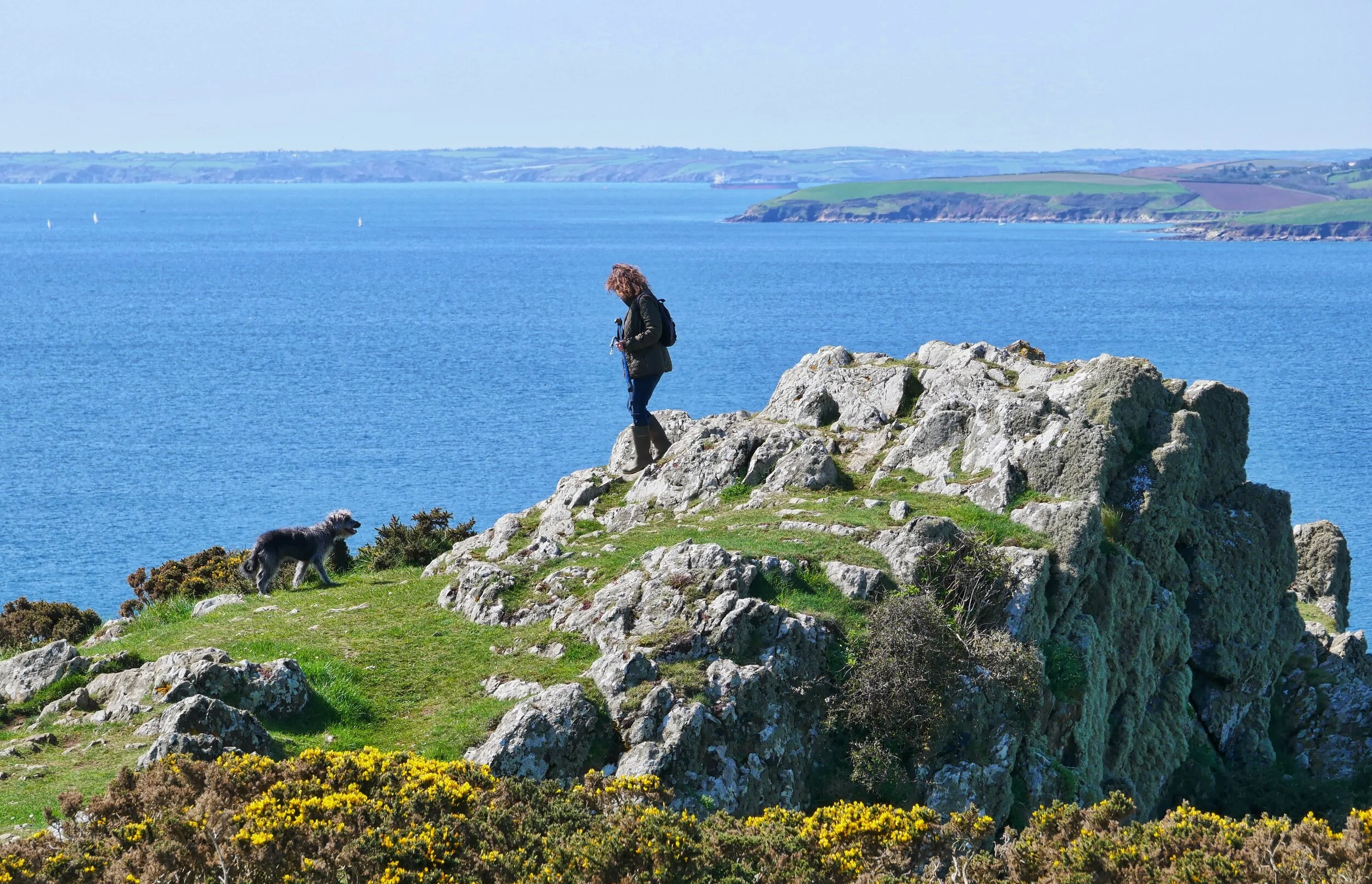
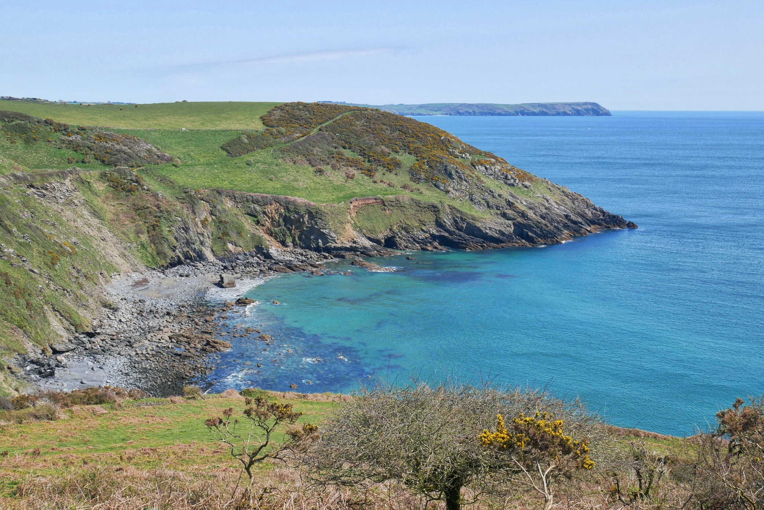
The West Country has a lot going for it. The peninsula is adorned with a plethora of fine features, from fertile vales to the great high moors. But it is the sea coast which acts as the most important mantle upon which the favourite jewels our crown are displayed.
Ask any visitor which single element of the West Country they identify with first and foremost, and the reply will probably have something to do with the seaside.
Unspoilt coves, big broad surfing beaches, picturesque harbours, noble headlands… Most visitors to the region will spend at least some time at the coast and it is generally recognised that the shores of the West Country are among the finest in England.
Which makes it all the more pertinent that we should mark the anniversary of the National Trust’s Neptune Coastline Campaign.
It was launched in May 1965 by Conrad Rawnsley, grandson of one of the trust’s founders, and it was designed to prevent “inappropriate development along unspoilt coasts.”
Anyone who has been to the littorals of Southern France, Spain or Italy will know just how crucially important this scheme was to prove. Compare, for instance, the wild and wonderful Cornish coast with the Cote d Azur section of shoreline stretching from Menton on the French-Italian border, a couple of hundred kilometres west to Marseille. Travel the whole of this over-developed coast and you will find only a couple of tiny areas of unspoilt countryside.
The trust’s original objectives were to focus public attention on problems faced by various seaside areas and to acquire control over the places deemed most worthy of preservation.
And Neptune has been hugely successful thanks to the generosity of landowners who’ve gifted property, and the public who’ve bequeathed monies in wills and made generous donations.
The original aim was to raise the sum of £2 million by voluntary subscription. In 1965 a survey of the 3,000 miles of coastline in England, Wales and Northern Ireland, showed approximately one third was already ruined and a third was of little interest. The final third of some 900 miles was deemed important to save.
The trust now owns just over 700 miles of coastline having raised a staggering £45 million through the Neptune campaign.
Fiona Reynolds, the trust's Director General when I wrote this article, said: “As a result of Neptune and the generosity of those who have supported it, millions of people are now able to access miles and miles of natural coastline of often stunning beauty. These landscapes represent some of the nation’s greatest natural and recreational assets.
“Sea Britain and the 40th anniversary of Neptune provide a perfect opportunity for the trust to celebrate the glories of these dramatic places. It is also the perfect occasion for the trust to provide a timely reminder that we need a different approach if we are to sustain the coast as a place of awe-inspiring natural beauty and a haven for wildlife.”
Just over 30 major seaside areas in Devon and Cornwall have been acquired by the organisation through the auspices of the Neptune campaign, and we’ll be finding out why they were bought and why it is so important that they remain carefully managed into the future.
After all, places like the tip of the Lizard are not only major jewels in the West Country crown – they are important treasures held dear by the entire nation.

Neptune in the West Country – all, or part of, the following coastal sites were acquired with help from the campaign.
Cornwall
Boscastle
Harbourmaster’s House (small part of larger ownership in Boscastle including harbour area, Valency Valley and cliffs either side of the harbour).
The Dizzard – 59 ha headland of stunted oak trees. Rusey Cliff – 97 ha.
Tremoutha - 32 ha of pastureland.
The Dodman
Dodman Point - 32 ha including Lower Penare Farm. Hemmick Beach – 17 ha dominating the two small valleys behind the beach. Lambsowden Cove - 28 ha.
Duckpool to Sandymouth
Houndapit Cliffs – 44 ha/108 acres of open farmland. Sandymouth car park and café.
Fowey
Coombe - coastal farm of 60ha /148acres. The Gribbin and Polridmouth. 48 ha/120 acres.
Godrevy to Portreath
Godrevy and part of Gwithian Beach (23 ha).
Lizard Peninsula and Bass Point.
Part of Bass Point including cliffs and quarter of a mile of coast including the Lizard Wireless Station.
Chynhalls Point & Cliff – 19 ha.
Lizard Point - Polbrean Hotel - now renovated and refurbished and the most southerly youth hostel in the UK. Tregullas & Tregominnion Farms (50ha) including Pen Olver headland.
Predannack – 273 ha/674 acres.
The Loe and Penrose
Higher Pentire Farm – 18 ha (part of extensive ownership including Loe Bar and Pool.)
Maer Cliff, Bude
45ha/115acres of clifftop pasture, with access to several small coves.
Morwenstow
Rectory Farm - the farm protecting the famous church of St Morwenna made famous by Reverend Hawker.
Mount’s Bay
12 ha/28 acres of coastal farmland at Trenow Cove (Boat Cove).
Nare Head, Gerrans and Veryan Bays
Portloe - 0.2ha of cliff land. Treluggan Cliff – 36 ha/89 acres overlooking Gerrans Bay – all part of extensive trust ownership at Nare Head, Gerrans and Veryan Bays.
Park Head
St Eval – 77 ha/192 acres of wild headland which forms the backdrop to Bedruthan Steps, including Pentire Farm and Diggory’s island with eight small coves and the rock-arch.
Pencarrow Head, Lansallos, Lantic Bay and Lantivet Bay.
73 ha of Lansallos Barton Farm and 50 ha of Highertown Farm.
Pentire Head and Port Quinn Bay
Lundy Bay - 8 ha of farmland above Epphaven. Trevan Cliffs - 4.4 ha / 11 acres completed the acquisition of a six mile stretch of coast.
Porthcurnick
Sandy beach and fields surrounding the beach acquired.
St Just in Roseland
48 ha/118 acres of farmland and 34 ha of farmland, foreshore and coast.
St Mawes
Nancorras Farm – (part of) 16 ha/40 acres.
St Ives to Pendeen
Bosigran and Carn Galver – 201 ha/498 acres stretching from St Ives to Lands End including the Iron Age cliff castle of Bosigran and Carn Galver tine mine.
Boswednack - 5.7 ha of cliff and farmland.
Carn Naun Point – 48 ha of cliff and farmland.
Rosemergy and Trevean cliffs – 81 ha.
Watchcroft – 47 ha of heathland.
Pendeen to Penberth
Bollowall, Carn Gloose and Cot Valley – 72 ha/176 acres of mainly cliff land once intensively mined for tin.
Boscregan Farm and Hendra Cliff – 28 ha/69 acres of cliff and farmland.
Carn Hoar (Escalls Cliff) – 3 ha/7 acres.
Levant – 3 ha/7 acres of traditional field system above the engine house.
Nanjulian Farm – 37 ha/90 acres of farmland, cliffs, coastline and an Iron Age settlement.
Whitesand Bay
Trethill Cliffs – 28 ha / 66 acres of farm and cliff land.
Devon
Avon Estuary to Erme Estuary
Higher & Lower Manor Farms 99 ha/245 acres of farmland and one mile of coastline. Plus Scobbiscombe Farm 200 ha /496 acres.
Branscombe
Part of Branscombe ownership (cliffs & coombes 89 ha).
Brixham: Southdown Cliffs
Cliff and farmland 47 ha /116 acres and 58 ha /144 acres.
Dart Estuary – Dartmouth
64 ha were bought in 1970 with Neptune funds and funds from a local appeal.
Heddon Valley: Heddon’s Mouth
North Cleave, with Parsonage Wood.
Lee to Croyde
Morte Point.
Salcombe
Bolt Head to Bolt Tail. 15 ha at Higher Soar Farm. Portlemouth Down. Prawle Point and Gammon Head. Snapes Point - all 63 ha/154 acres.
South Milton
Wembury Bay and Yealm Estuary.
Woody Bay – 49 ha /120 acres.