Exmoor Walks: Ruin Which Is The Capital Of Nowhere

The official Twitter account for Exmoor's 3 National Park Centres #Lynmouth #Dulverton & #Dunster is running an excellent lockdown quiz at the moment in which they put a photo a day up on to their twitter account and people who see it have to guess the location…
The other day they put up a photo of Hoar Oak Cottage, right out in the middle of the western moors, and it reminded me of the day a few years ago when I walked in that direction with Dr Nigel Stone, who was at the time chief executive of the Exmoor National Park Authority (ENPA). He’d invited me to join him so we could see some of the work which had been done to help celebrate the 40th anniversary of the Two Moors Way.
If there was a competition category for Britain’s most beautiful, but least known, long distance trails - this north-to-south route would probably win it. The Two Moors Way was relaunched a couple of weeks ago 40 years after its inception, with a new logo that promises that the trail will take walkers from coast to coast.

View of the young Exe from Prayway Head
The fact that it doesn’t will take nothing away from the path which wends its way south from the West Country’s north coast at Lynmouth - across Exmoor, through the middle of Devon and over Dartmoor - to terminate at Ivybridge. But walkers must then join the Erme Trail to hike the extra 15 miles to the south Devon shoreline at Wembury.
A great deal of work has been done to make the Two Moors Ways just that little bit easier and more pleasant to follow. And Dr Stone and I set off over the high moorlands above Simonsbath to see the improvements for ourselves.
We did one of those two-car jobs to make things easier - an obvious boon if you are hiking with other people because it allows you to enjoy a linear route rather than always having to find some circular ramble that takes you back to where you began.

On this occasion we left one car at Brendon Two Gates on the Simonsbath-Lynmouth road, then drove back south to Prayway Head where there’s plenty of room to park.
I don’t know why the dramatic spot above the young Exe Valley is called Prayway - but can guess it was named thus centuries ago by folk who reached this spot, then had to continue out across the featureless Chains. In bad weather, before the bogs up here were messed about with and semi-drained, this would have been a somewhat perilous thing to do.

Actual headwaters of the River Exe
Many of the bogs remain - indeed, this whole area is being re-wetted as part of Exmoor’s Mires Project in a bid to restore the natural balance of this landscape to how it should be - but the scheme is a long way off the point where bottomless pits will swallow you whole, Hound of the Baskervilles style.
Nevertheless, the work being carried out up here on the Two Moors Way is all about preventing walkers sinking knee-deep in mud. This we were to see after we’d strolled west across Dure Down. As we reached Exe Head - the damp birthplace of the West Country’s greatest river - so we noticed the bags of aggregate which will be used to allow the Two Moors Way hikers to pass the boggiest bit of this wet corner.
This is not a major engineering project - once the work is done you’ll be hard pushed to notice anything has changed, so it won’t take anything away from the wildness of the place - but it will make all the difference to walkers.

Doesn’t look much but this is the beginning of the South West’s most mighty river
At Exe Head we’d reached the Two Moors Way, so we turned north along it to drop down into the dramatic looking coombe that divides Exe Plain from The Chains. If you are looking to experience a sense of deep wilderness - but don’t want to have to walk miles from a road - this is a prime place in which to do it.
It’s just a 15 minute walk to this spot from Prayway Head, and yet stroll down into this coombe and you can imagine you’ve travelled into some prehistoric Britain. It’s as wild and as beautiful a place as any I know.
A little way down the steep sided ravine there are the remains of an old cattle keep - if that really is what the low stone walls represent. Whatever the place was, it gives the scene an even more antediluvian feel because you are now deep in the valley and so can see nothing else man-made at all. There are cattle and sheep, but they somehow have the appearance of wild beasts wondering out on some Serengeti style plain…

Old cattle pound above Hoar Oak
Down along this part of the long distance trail we were able to see more of the ongoing work which will help the Two Moors Way become more passable. Those cattle have turned some sections into long linear bogs - but, thanks to a recent crowdsourcing exercise, a helicopter was hired to bring in bags of aggregate which will help drain the worst bits.
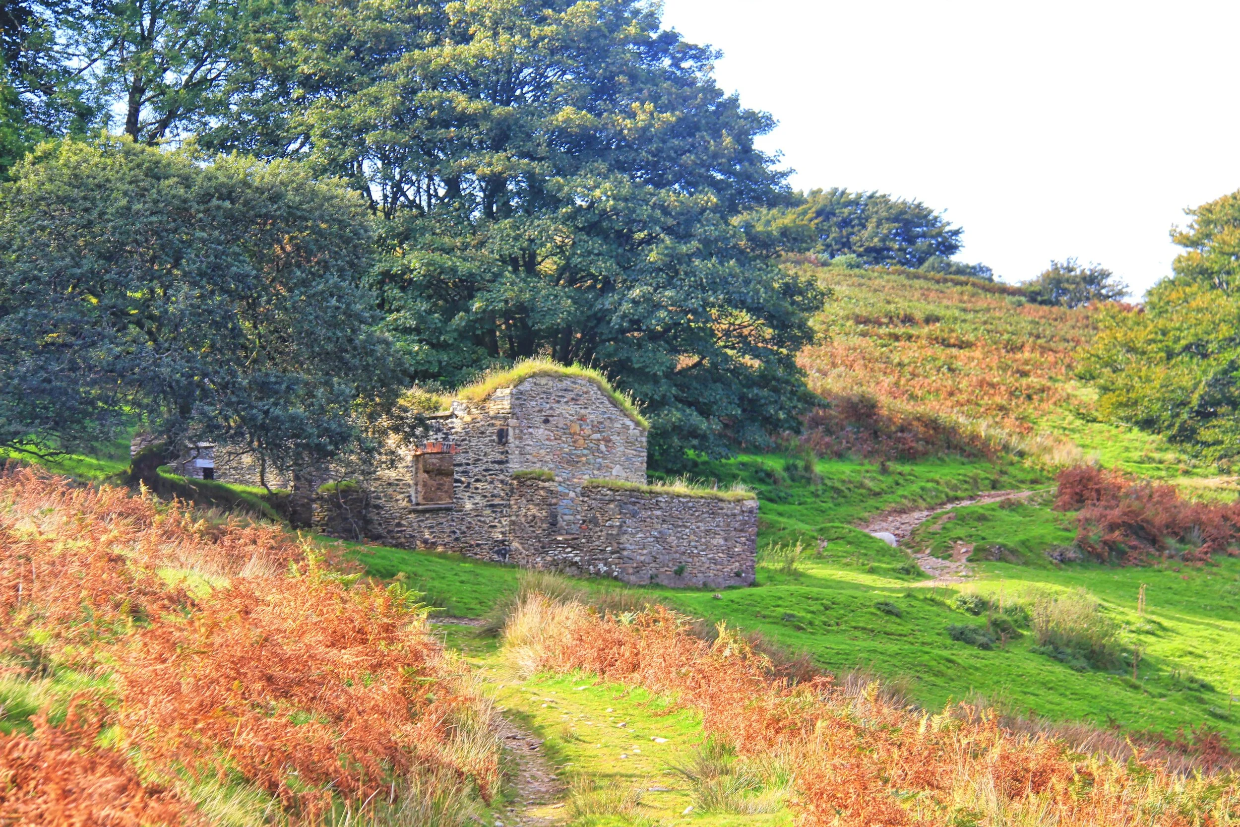
Remains of Hoar Oak Cottage
Just as the hiker is now thinking it would be impossible to feel any more remote, the trail comes up with another chapter in its book of loneliness. I refer to Hoar Oak Cottage, an ancient moorland home which has played host to all manner of tales and legends - to the extent that it has become something of an enigma with its own dedicated website and a society of friends.
The semi-ruined cottage - which I described as “the capital of the Middle of Nowhere” in a newspaper head-line - underwent refurbishment work a few years ago to stabilise its fabric. The ENPA worked with the Friends of Hoar Oak Cottage, the Exmoor Society and Exmoor Uprising to agree a way of stabilising the ruin.
This was the first time I’d visited since the work was completed, and I think it was sensitively done. The empty shell would have simply dissolved into the landscape without trace - now it’s still a ruin, but one that will stay that way for many years to come. And walkers can explore its roofless rooms, see the little fireplaces, peer out of the empty windows - and experience the profound sense of loneliness and remoteness that living in such a place must have engendered.

Valley below the ruined cottage
For Nigel and I it was a case of getting back to modern civilisation by heading east - up over the open access moorlands past Clannon Ball, all the way to Brendon Two Gates. Given the time and the choice, though, I’d have preferred to hike right on down to Lynmouth which is where the Two Moors Way begins or ends.
If course we are all meant to be in lockdown a the moment - so I would ask people not to drive out to visit the moors. But if you’d like to listen to a short story that includes quite a bit of the Two Moors Way, you can find it by clicking play below…

Bags or hardcore were helicoptered in to repair muddy parts of the Two Moors Way