

Cornish Walks: 6 Great Hikes for Easter and Spring
Walk 1 - Boscastle West - North Cornwall
It is easy to leave the crowds behind if you walk in almost any direction from busy Boscastle. One dramatic way is to venture west around the vertiginous headland called Willapark that borders an area of medieval field strips called Forrabury.

Leaving your vehicle in the village’s big car park you soon begin to see why the place is the only navigable inlet along 40 miles of coast. The thin, winding, rocky “fjord” which makes up the harbour is almost impossible to see from the ocean.
Boscastle's fortunes were greatly improved in 1584 when the squire Sir Richard Grenville built the inner, southerly quay which still helps keep out the swell to this day.

It’s to the southern quay that we walk on this short stroll. Beyond the harbour the coast path climbs to the top of Willapark, which is crowned by the a white square look-out building. It was put here in the 1820s by Thomas Avery (a merchant and some say successful smuggler) as a summer house with exceedingly dramatic views. It’s believed that the design was borrowed from the nearby church tower.

From this vantage point we continue along the coast path for five minutes, crossing the seaward section of The Stitches – which is the local name for the open medieval field system. At the far south-west corner we turn left to follow the grassy path across to Forrabury Church – a temple of Norman origin which still boasts some very early features.

We pass the church to turn right into the lane that will take us south to the main Tintagel road, where we turn left and cross to Paradise Road, which in turn takes us east to Boscastle’s old High Street. It’s all downhill from here to the lower, and far better known, part of the village.
Distance: 2.5 miles. Time: 1.5 hours. Difficulty: 3/10

Typical Boscastle shop
Walk 2 - Cape Cornwall Mines Walk - West Cornwall
A mile from the village of St Just a lane descends to reveal the glories of England's only Cape. Singular though it may be, it's a dramatic enough place from which to start a walk which, in this case, takes us north along the South West Coast Path.

There’s a car park on the shoulder of the Cape and all we have to do to begin this walk is round the corner north and follow the path deep into a valley cluttered with old mine buildings.
The basic walk takes us from Cape Cornwall, north along the coast path to Lelant and Geevor Mines, then inland up to Carn Kenidjack on Penwith Moors before returning via footpaths and lanes to England’s only Cape.
It’s quite a long hike at around 10 miles, but relatively easy going. Once past the valley we are able to enjoy our first view of The Crowns. This is the headland where two of Cornwall's most dramatically situated tin-mines cling to the cliffs.
A mile or so north and we can learn all about the tin mines whose remains dominate this landscape by visiting the National Trust's Levant Mine. The old engine house has now been restored and is run by a team of volunteers.
Here we can watch the great beam engine slowly, and almost silently, see-saw away in a re-enactment of how things were when men would descend almost 2,500 feet to bring out the tin. You will be shown the surprisingly small hole they went down so that they could walk, or crawl, some miles out under the seabed.

Just north-east of Levant is Geevor, one of the last tin-mines in Cornwall to close. With the help of grant-aid, a group of ex-miners and enthusiasts have kept the place open as a tourist attraction.
After Geevor our route follows a footpath inland, across the B3306 and up the hill onto the Penwith Moors. We cross Trewellard Common and the B3318 Penzance road to climb Carn Bean on Carnyorth Common.
Nearby we can visit Carn Kenidjack with its ancient stone circle, before finding the footpath that descends towards the hamlet of Tregeseal. From here we take the lane to Nancherrow where a further lane takes us west back to Cape Cornwall.
Distance: 10 miles. Time: 6 hours. Difficulty: 7/10

Walk 3 - Frenchman’s Creek - South Cornwall
Pure unabashed, unashamed romanticism, that's the theme of this hike. Frenchman's Creek has more of novel's atmosphere than any other literary waterside location.

If the tide is out the place literally oozes with the stuff of legend. If it's in then the shimmering tranquillity allows you to mentally plunge straight into the derring-deeds of Daphne du Maurier's brilliant tale.
I recommend taking the little foot-ferry that plies across from Helford Passage. There's something special about arriving at the beginning of a walk by boat and anyway, the hamlet on the north side of the river-mouth is a lot easier to get to than the alternative of negotiating the tortuous lanes of the Lizard peninsula.

Helford Passage Ferry
It only takes a couple of minutes to cross to Helford. Du Maurier wrote: "Helford hamlet was no inducement to a sailor ashore, the few cottage folk dull-witted and uncommunicative..."
There's nothing dull-witted about the person who can afford one of those cottages now. A lane leads along the creek, past the pub and picturesque abodes, and eventually crosses a stream at a point close to where a footpath sign points to Manaccan. We take the track through the trees until a junction allows us to turn right into Under Wood and climb the hill towards the farm called Kestle which is an ancient farm full of character situated on the ridge of hill that divides Helford from Frenchman's Creek.

Walking through the old farmyard on the public footpath the thought struck me that Du Maurier’s description of walking to the creek fits exactly with the track that leads west from Kestle, down over the hill and into the trees:
"Yes, there once again was the glimmer of water that had surprised her. The trees were thinning, she was coming to the bank - and there, suddenly before her for the first time, was the creek, still and soundless, shrouded by the trees, hidden from the eyes of men."
The National Trust owns the woods that run from Frenchman's Pill up the eastern bank to the creek and its staff have laid a path along the waterside so that we can enjoy its hidden secret delights as long as we are willing to make the effort of walking there.
After half a mile or so the path departs from the waterside and hauls itself up the hill to meet what must be a drive to a hidden house. Turn right here and follow it up to a junction and take another right to follow the road another few hundred yards until you see a public footpath sign upon your left.
This takes you down through yet more Trust-owned property - again, deep and beautiful woods - until the right-of-way deposits you in quaint Penarvon Cove.
Now it's simply a matter of taking the track to the right which will lead you the quarter-mile or so back to the ferry landing-stage.
Distance: 3 miles, Time: 1.25 hours. Difficulty 2/10
Walk 4 - Lelant to St Ives
Let the train take the strain – a fine recommendation if ever there was one, and one particularly well suited to walkers who complete this fantastic linear hike. We refer, of course, to the St Ives branch line which leaves the main line at St Earth, but which soon makes its first stop at Lelant.

The best plan is to leave your car at Lelant Church on the edge of the dunes (where there’s just room for a few vehicles) and proceed west from there. This is actually the beginning of the trans-peninsula St Michael’s Way which takes walkers overland from Lelant to Marazion and St Michael's Mount.

Lelant where the walk begins
Lelant Towans plays host to a splendid golf course, and it’s across the eastern end of these links that we stroll to make for the estuary mouth. There’s a choice of paths – but whichever you take, watch out for golf-balls.

St Ives from Lelant sands
A shortcut runs through the middle of the links, but I stuck to the coast path which begins its journey to St Ives on the sea side of the railway. You go down a lane towards the waterside, but turn left as soon as you’ve on passed the tracks. The path now climbs onto the dunes and follows the sandy escarpment west to where the cliffs take over and put an abrupt end to Porth Kidney Sands.

Hayle Towans from the other side of the bay while on the walk
Now the coast path threads its way through a sort of leafy tunnel on the edge of the cliffs under the railway. At one point we are high above the beach – at another, the path goes down to almost reach the sand – but finally it climbs to a high point at Carrack Gladden.
This triangular knoll of a headland is divorced from the rest of Cornwall by a deep railway cutting and the walker is faced with a choice of either following a footpath along the man-made gulch, or continuing along the coast path which winds off around the point.
The headland introduces us to Carbis Bay – or Barrepta Cove, as it used to be known. After that the path climbs a steep rap out of the bay area and takes walkers across the line and onto a private road that runs between a number of posh looking homes. The woods of Porthminster Point no longer provide a shelter belt for the huers and criers, but their old stone hut remains on its shelf above the bay. From here the older members of the St Ives fishing community used give directions as to the whereabouts of the schools of pilchards that were so huge they’d turn the bay red.
With a bit of a zig-and-a-zag the path descends to Porthminster Beach which is dominated by the timely railway station. Trains run regularly but, if you’re lucky, you’ll have an hour or so to walk into town for well earned refreshment in one of the many watering holes. And then it’s off back to Lelant on a five-minute ride of spectacular proportions. Either that – or walk back.
Distance: 4.5 miles. Time: 3 hours. Difficulty: 4/10

Walk 5 - Minions - Craddock Moor
Occasionally some of us like to climb to the roof of the world - and in the West Country the roofs don't get higher than the ones in Minions, which is Cornwall's highest village.

M
This walk begins at The Hurlers on the edge of Minions. It's not often you can view three stone circles in a row and archaeologists remain baffled by the seemingly excessive erecting of stones.
Local legend suggests God was so angry when local men dared to ignore his Sabbath by playing the heathenish game of hurling - he turned them to stone. Another legend claims it's nigh on impossible to count the Hurlers, but should you do so correctly, some terrible misfortune is likely befall you.
This hike takes you from Minions, north east around the hills until we arrive above the hamlet of Sharptor - and from there, west to Craddock Moor and back via Tregarrick Tor.
Thousands of miners were drawn up here in the 1800s by the promise of riches from all over Cornwall. There are few historical records of the shanty towns that grew up, but accounts show that over 650,000 tons of copper ore was mined in less than three decades.
After that the moor was returned to sheep and ponies, ring ouzels and larks. And to hikers who can enjoy seeing traces of all this industry as they walk north-east to find the disused railway that leads around the hill to the Cheesewring Quarry. Rock from this impressive place found its way into the fabric of Westminster Bridge, Tower Bridge and the Thames Embankment.

The quarry gets its name because of the great stack of rocks perched high above the workings - but we proceed north along a small path through the clatter of rocks. This eventually curves around to the west leaving us high on a promontory overlooking the village of Henwood and the hamlet of Sharptor.
Now we walk around the north of the spur and find ourselves descending onto a high plain. There's no path, so we must pick our way among the rocks. To the west, on a low hill, there's a quarry and we head for this ascending Craddock Moor a little to the south. In this way we cross the low ridge and are treated to yet more views all the way down to the Dodman peninsula in the south - and to the wind-farm above Newquay in the north.
Now march down over Craddock Moor to Tregarrick Tor where we have a choice: to drop down to Siblyback Reservoir and make our way around to Cryna Farm where a public footpath will take back to the Minions road via Great Gimble. Or to turn tail to re-cross the moor to The Hurlers and be rewarded by extensive views of the English Channel coast past Rame Head.
Distance: 5 miles. Time: 2.5 hours. Difficulty 6/10

Walk 6 - Fowey - Bodinnick - Polruan
This is one of the West Country’s true classics – and one of the first hikes I did for this newspaper 15 years ago - a hike I shall return to enjoy for as long as I can put one foot in front of another…

Bodinnick Ferry
The Fowey, Bodinnick, Hall Walk, Pont Pill, Lantic Bay and Polruan circular has just about every type of view imaginable save for craggy moorlands. There’s not one but two ferry rides – and there is something special about combining a walk with being afloat, no matter how briefly. There are quaint Cornish streets, some of the best estuarine views in the region, beautiful old woodlands, forgotten quays, an ancient church, high airy heaths, a truly oceanic coast path section and picturesque harbour-sides lined with welcoming pubs.
We begin by catching the Bodinnick Ferry which crosses the river from Fowey towards the community that gives it a name with its ancient inn and Daphne Du Maurier's old home, aptly named Ferryside.

Now we must haul ourselves up the steep street that runs past the inn until we see a signpost for "Hall Walk" on our right. This is a wonderful path which meanders along the top of the oak woods towards Polruan at the estuary mouth. Every few yards there's yet another breathtaking view of the river far below, with Fowey busily going about its business on the other side.
A thousand tales of swash-and-buckle can be imagined while walking along here - like the derring-deeds of Elizabeth Treffry back in 1456 when the French were attempting to take the town. With her men she climbed onto the roof of her fortified mansion and poured molten lead onto their heads and so repulsed the attack.


Hall Walk brings us, eventually, to Pont Pill - a little known limb of the Fowey estuary that forces our path to veer east to the hamlet at the head of the creek. It is difficult to imagine that dozens of sailing ships once traded up and down to this remote and peaceful place carrying coal, fertiliser, limestone and timber and taking away fresh local produce.
Next comes a climb, due south, up to the church of Lanteglos-by-Fowey, where we turn left along the lane to reach the National Trust car park up on the Polruan-Lansallos road. Turning right along the roadside footpath we reach the right-of-way that takes us across a single field to join the coast path.

Far below you will spy Great and Little Lantic Bay beaches, bordered by Pencarrow Head to the east and Blackbottle Rock to the west - a view that seems to offer all that is best about the South Cornish coast.
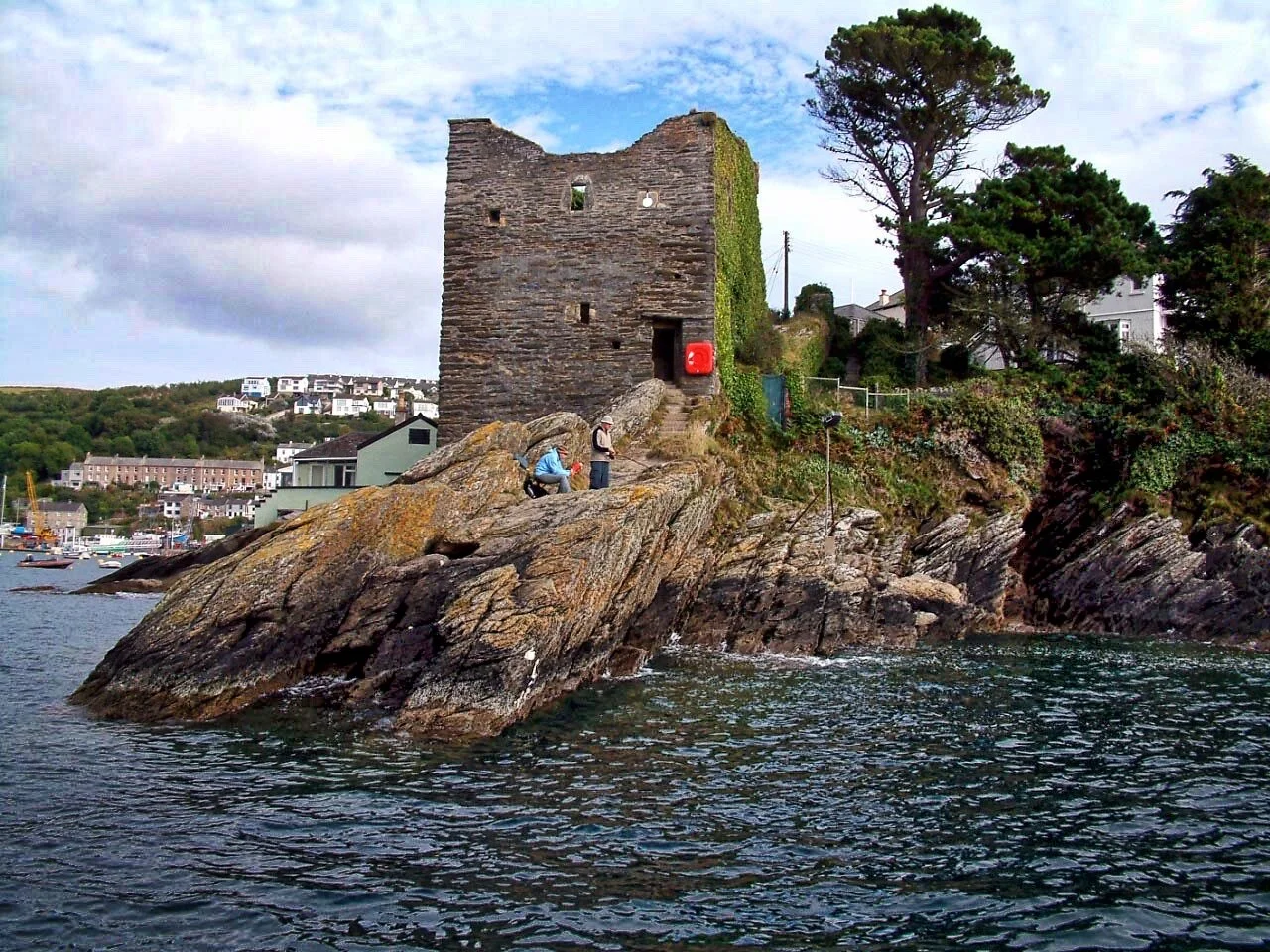
We head west to the quiet seaside of Polruan passing Washing Rocks before descending towards the mouth of the estuary, passing the famous old Blockhouse, before entering the centre of the comely little port that sits opposite Fowey.
All that's left for us to do now is linger while awaiting the lower-ferry (foot passengers only) - perhaps enjoying a pint in the Lugger Inn - then, having crossed to the other side, it is just a matter of wending our way through Fowey's pleasant and busy streets back to the higher ferry where we began.
Distance: 5 miles. Time: 3 hours. Difficulty: 4/10

Polruan

