

Exmoor Walks: The Chains and Pinkery Pond
Exmoor's Wild Beauty: A Walk Through The Chains and Pinkery Pond
"There must be some kinda way outta here..." growled Jimi Hendrix, as we slipped across the snowy wastes in the big air-conditioned limousine. And somehow poor old Jimi, who I hadn't heard for years, managed to capture the theme for this hike.

Exmoor area The Chains in winter
A walk on Exmoor's most desolate bog in a deep freeze had inspired those sentiments both in me and in my city friends who had insisted on visiting The Chains.

Path to Pinkery Pond
Actually, we'd got off lightly I learned later. We'd crossed impenetrable bogs deep enough to drown a horse - but these moisture laden hell-holes were frozen solid so we remained high and dry.
Exploring The Chains: Devon's Remote Hiking Adventure
But cold. So cold that the laces on our boots froze into solid steel chains. Apart from one or two higher parts of Dartmoor, The Chains provide we wilderness fans with our wildest spot. Which is why I say - go there. Wrap up warm, be careful, and enjoy the very best that primeval, unspoilt, untainted, Britain can offer.
The Chains are the great swathe of moorland that lie to the south of Lynton and Lynmouth - slightly north-east of the isolated vilage of Simonsbath. The natural high altitude reservoir that soaks up the rain.

A stream comes down from Pinkery Pond
The series of peat bogs that lie between Exe Plain and Rowley Down are deluged by more precipitation than anywhere else in the region. Their overspill killed 36 people in the infamous flood disaster of 1952.
In short, you don't mess about with The Chains. You give them a wide berth and plenty of respect. No one lives there and few people go there except for the odd shepherd who's lost a sheep. And walkers of course. It is wonderful walking country, but you must go well prepared.
We had a map, but no compass and that could have been a mistake as this is one of the only places south of the Penines where I'd advise taking one. The map isn't that much good either, to be honest, because this wild place holds secrets the cartographers didn't locate.
Like the bridleway that sets off over Dure Down from the lay-by on the B3223 Simonsbath-Lynmouth road. You'll see this parking place perched rather dramatically on the brink of Preyway Meads about a mile up and out of Simonsbath. Preyway Meads get photographed a good deal and are one of the River Exe's most sensational moments.

South of Pinkery the valley slopes into the moors
The bridleway doesn't get a mention on Ordnance Survey's otherwise excellent Outdoor Leisure Map 9, but follow the sign anyway, for the path will take you deep into this high, cold, secret wonderland.
Well, it will put you on your way at least. After the first field the right-of-way disappears and you are left to negotiate the barren wastes of Dure Down on your own. It's basically a matter of keeping the gentle rounded peak of the hill slightly to your right - and after ten minutes of walking you'll find yourself gazing down on Exe Head.
This is the source of the River Exe, and a disappointing little dribble it is too. The sort of place where woolly, suspicious cattle come to sip and pooh. But we are not here to admire details. We are here to take in the big picture, the great expanse, the vastness of this roof of the West Country.
My pal was most pleased to have stumbled upon this lonesome mire, as she is an art-student and her aim was to walk in the footsteps of a famous artist called Richard Long. Mr Long's mission in life is to do curious things like walk in a dead straight line for 10 miles, and at Exe Head we were more-or-less on one of these celebrated routes.

Pinkery Pond: A Hidden Gem on Exmoor's Rugged Landscape
Why Mr Long should want to walk in a dead straight line for 10 miles I have not been able to fathom, save for the memory of reaching a distant tower without a single bend of deviation when I was a boy. But all this was most important to Gill, so off we trotted - due west along the line and along the footpath that leads to Pinkery Pond.
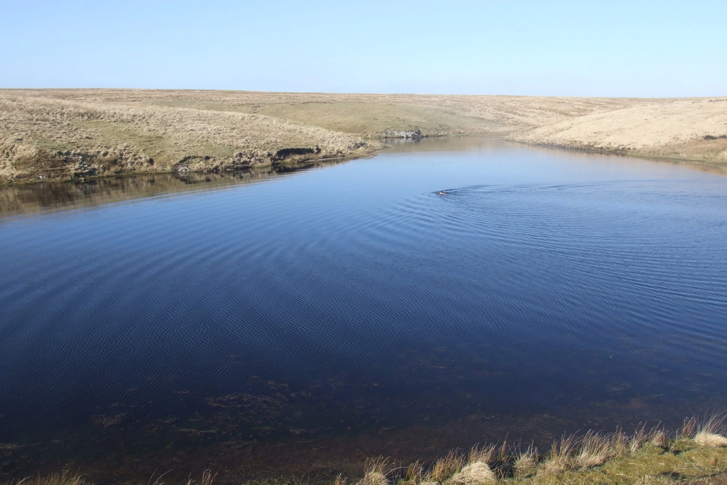
We have been to the region's highest, remotest stretch of water before but not from this angle of the dangle. In the bright cold sunshine we sat on the old dam and ate Parma ham sandwiches, and while my friends talked to a solitary hiker who adamantly refused all nourishment save for a single cherry tomato, I thought of wretched Richard Gammin whose body was found in the peaty depths 103 years ago.
This well respected farmer was left a widower with 10 children to raise. After six years the loos of his dear departed wife was obviously beginning to cut deep, and he sought the attentions of a young Parracombe girl. Her letter, refusing his offers of love, was found in his jacket by the side of the lake. Lynmouth lifeboat sent up a small boat so that the depths could be dragged, a diver from Wales was brought in - all to no avail. There was only one thing for it - Pinkery Pond had to be drained.

Pinkery Pond
The Knight family who'd built the dam had equipped it with two plug holes, but nothing could budge the bungs. Teams of horses were attached to chains, but the iron rings on the plugs simply broke off. Eventually brilliant Bob Jones, the man who built the Lynton-Lynmouth Cliff Railway, was brought in and he devised an elaborate system of rams to push the bungs out from the other side of the dam.
And so Pinkery Pond was drained on the first of just two occasions in its long history. The remains of heart-broken Mr Gammin were found and the herons came in flocks and ate all the fish.
But what I find curious and not a little disturbing is that upwards of a thousand people turned up to watch the morbid scene unfold. They must have marched for miles to get to one of the most remote corners of the region - just to see a body hauled from the mud.

I'd be one of the ones marching the other way - and that is just what we did. March on westwards up to Woodbarrow Gate, and there we turned north along the path that leads down to the Saddle Stone. The plan then was to turn right and head east to Ruckham Combe, over Thorn Hill, past Benjamy down to Hoar Oak and then follow the Two Moors Way back up to Dure Down. But the paths were all obscured by snow and it was late and cold.
So I came up with the bright idea of cutting straight across The Chains from the Saddle Stone to Exe Head. Don't do it. Jimi Hendrix's words - there must be some kinda way outta here - will haunt you. Or you will sink in a boig and never be seen again.
But the views were tremendous - we could see deep into Cornwall and deep into Wales with a mere turn of the head, and there aren't many places where you can do that. The moon came up and the sky turned a rather odd lime green and I wondered how my newspaper would cover the fateful demise of it walks writer - lost on a frozen, barren heath.
But at last we regained the big posh car and within minutes were were thawing our toes by the fire on an ancient Exmoor pub, and my pal Tim Bannerman was so moved by the experience he wrote a poem about The Chains the first lines of which go like this:
"Wet life forces through the softer rock,/
into an open mind the wind/
catches like a flint,/
to spark the skylight into flame."
Fact File
Basic hike: from road by Preyway Meads west across Dure Down to Exe Head and on to Pinkery Pond, then from Woddbarrow Gate north to Saddle Stone and then east to Hoar Oak before swinging north back up to Dure Down.
Recommended Map: Ordnance Survey Outdoor Leisure 9.
Distance and going: 12 miles, extremely arduous in places.


