


Grand Tour of Gran Canaria

The world is full of geographic misconceptions, which is partly what makes travelling such fun. For example, mention the Canary Isles and most people will imagine concrete vacation resorts located on arid coasts loomed over by barren volcanic mountains.

And that is an accurate picture in some places, like the busy southern half of Gran Canaria – but go to the northern part of that huge and impressive island and you will come across a very different landscape indeed.
Think green. Think boundless mountainsides covered in flowers. Think running water tinkling through pretty villages perched on the sides of dramatic gorges. Think almond blossom gleaming all white and lovely in secret coombes two thousand feet above the sea. And, higher still, conjure an image the cool green scented zone of coniferous cloud forests wafting in the warm breeze.
In the depths of a northern hemisphere winter you could claim that the Canaries offer the very best country-walking to be found on the planet, without crossing the equator. Go to the tropics and things get too hot – go north and you can freeze. In winter the islands have what has been described by top meteorologists as the best climate on Earth.
A week striding about the high sierras of Gran Canaria is just about the best tonic for the winter’s-gone-on-too-long blues I can imagine. They call it a “miniature continent” because of its amazing array of different climates and landscapes. The round, dart-board of an isle is built around a massive volcano system which rises, at Pico de Las Nieves, to an impressive 6,390 feet.


Just about half the land area, 667 square kilometres, falls under the Canary Islands Network for Naturally Protected Areas. In total Gran Canaria has 33 protected areas including a couple of large national parks.
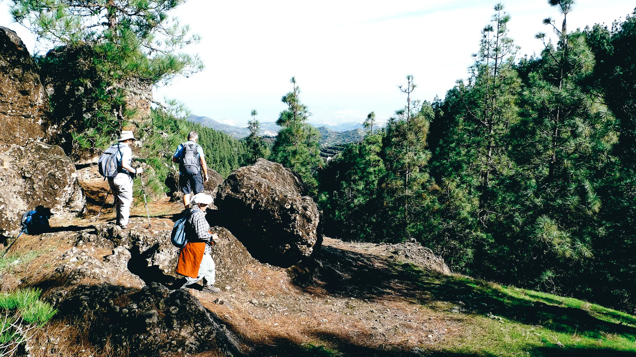
It was into this little lot that I went marching with a group from Ramblers Worldwide Holidays (RWH). By using either chartered minibus or the excellent public transport system, our guide took us up, up and away into the great hinterland of northern Gran Canaria where the walking is altogether more green and picturesque than you find in the south.
On day one the bus took us all the way up to Cruz de Tejeda where a carved stone cross on a mountain pass marks the 5180 foot contour. Not surprisingly, the vantage points around this altitudinous place offer magnificent views. And the area is surrounded by marked walks, some new, most of them caminos reales (royal paths) - ancient tracks built by the farmers of old.


You will see the remains of their terraced fields and orchards nestling on steep slopes far below, but it’s a shame to report that many of these have fallen into neglect.
Our walk took us over a nearby ridge to the north and then down long and lovely slopes to the charming town of Teror. Almost the entire route is a descent and after some 3000 feet you begin to feel certain parts of your lower body you may not have noticed for years.
Not that anyone was complaining – this was a walk of great beauty, passing through peaceful pine forests and then, beyond the village of Lanzarote, deciduous woodlands.

Teror was a delightful place in which enjoy a cold beer. The small town is full of colonial-style architecture which surrounds the Basilica de Nuestra Señora del Pino, dedicated to Gran Canaria’s patron saint. In 1481 some shepherds saw a vision of the Virgin Mary sitting hereabouts atop a pine tree - since then Nuestra Señora del Pino (Our Lady of the Pines) has been the great religious icon of Gran Canaria.
Our second walk was the big one of the week – a fairly arduous 12-mile ascent and descent across a high pass that took us from Barranco de Guayadeque to Tenteniguada. It began in one of the island’s most magnificent valleys – a deep ravine that boasts all manner of cacti, agaves, palms, pines and almond trees.
It was also once home to the early humans who first settled on the island and is the setting for various cave villages and inaccessible cave burial sites.


We started the walk at Tagoror where there’s a famous cave restaurant, as well as several troglodyte homes which are still inhabited. From here on up, the gorge’s great cliffs began to close in. Eventually we passed a couple of small, unbelievably remote, hamlets and then it was on upwards again into the wilderness.
There is something mildly disappointing about coming across a road after labouring for so long up a mountain, but this was mollified at the Calle de Telde Los Pechos by the fact that the high ridge boasts its own dramatic volcanic basin.
We picnicked near this in the cool shade of the pines, before beginning the long and picturesque descent to the little town of Tenteniguada.
Our third walk took us up to the Fontanales area of the island, probably the most luxuriant and verdant zone in the whole Canarian archipelago thanks – as the name suggests – to the many springs which pour forth here.
This was another down, down, route – eight miles all the way from the highland village of San Bartolome de Fontenales to the town of Firgis, which is famous for its mineral water, drawn from a spring in Barranco de las Madres.
It’s one of the gorges we crossed in a steep descent and ascent – and its depths were as silent and peaceful as a tomb. You could not possibly imagine that you were on the same isle as all those British tourists just 20 miles to the south. Ruined cottages punctuated the way and the whole place was like a zone time had forgotten – thankfully, though, most of the footpaths were passable, even if the local farmers have long since given up using them.


Our fourth walk was perhaps the most strange. It took us down into the depths of the Caldera de Bandama – a massive and perfectly formed volcanic crater, 3281 feet in diameter and 656 feet deep.
We took the steep path down into this circular world – walking through palm, orange, fig and eucalyptus trees on the way. The floor of the crater showed signs of having once been extensively farmed and old buildings in various states of disrepair still poke out among the groves. Surprisingly, one was still occupied – though how it’s ancient resident gets in and out of the vast inaccessible bowl for a pint of milk, none of us could imagine.
Having done the circular tour inside the volcano, we climbed back to walk around the dramatic - and at times scary - ridge surrounding it.


In places this path shrinks so that it’s not much wider than a tabletop – with a steep drop of at least 600 feet on either side. Perhaps most strange of all was that the end of this walk took us through a beautifully manicured golf course. The Real Club de Golf de Las Palmas is the oldest golf club in all of Spain, having been founded at the end of the 19th century by members of an influential English colony.
To round off our walking tour of Gran Canaria we did a short steep five miler on the dramatic north western edge of the isle. It took us up a mountainside above the pleasant little town of Agaete then down across a great shoulder of rock to Puerto de las Nieves, which acts as both a ferry terminal and fishing village for this remote part of the coast.


The port has a long history and is something of an excursion venue for islanders. On Sunday lunchtimes its many fish restaurants are packed to the gunnels – which suited me, as I elected to laze away the afternoon enjoying excellent Spanish seafood and soaking up the busy atmosphere rather than traipse along a rather bleak bit of coast.
According to a study carried out by climatologist Thomas Whitmore of the USA’s Syracuse University, northern Gran Canaria enjoys "the best climate in the world". I wouldn’t disagree - but would add that it enjoys a great more besides. Like the excellent walking through truly fabulous scenery.


