

The Wreckers' Coast of Devon and Cornwall
The “Wrecker’s Coast” that thrusts it’s razor-backed rocks out into the Atlantic between Hartland Point and the Camel Estuary boasts some of the most dramatic and savage coastal scenery to be found anywhere in Europe.
The list of local shipwrecks at the Hartland Quay Museum is enough to bear witness to the savagery of this littoral.

Heading for Hartland Quay we pass a small building just before the road descends to the pub and the museum, and in a way the place helps tell part of the coast’s story. The Rocket House, now a modest dwelling with a big view, was once the home of an award winning rescue service known as the Hartland Life Saving Apparatus Company.

Before the days of the RNLI and helicopters, rockets were a shipwrecked sailor's best friend, reaching the parts of a sinking ship that other methods simply could not. Needless to say, the rocket squads who worked from here were among the busiest rescuers anywhere in the country, firing their rockets and lines to many a vessel swept onto this windward shore.

The museum at Hartland Quay was founded in 1980 in order to preserve material relating to the history and character of this extraordinary coast. It occupies two upper rooms of the historic quay buildings, which once housed the families of coastguards, labourers and tradesmen in the days when the place was once – amazingly, given its crazy location - a thriving port.

Turning south along the coast we come to Screda Point, before descending to the strange demesne around St Catherine’s Tor – a steep hill that’s been chopped in half by the sea.

On the other side of the tor there’s Speke’s Mill Mouth with its waterfall, which is one of the tallest in the region. The views south are certainly of the stunning variety, the cliffs are contorted into an insane and rocky dance. I was reminded of something I’d read in the Handbook for Travellers in Devonshire written by a J. Murray in 1879. “No words,” say Sedgwick and Murchison (whoever they were), “can exaggerate the number and violence of these contortions, - sometimes in regular undulating curves - sometimes in curves broken at their points of contrary flexure, and exhibiting a succession of cusps, like regular pointed arches.”

Speke’s Mill Mouth
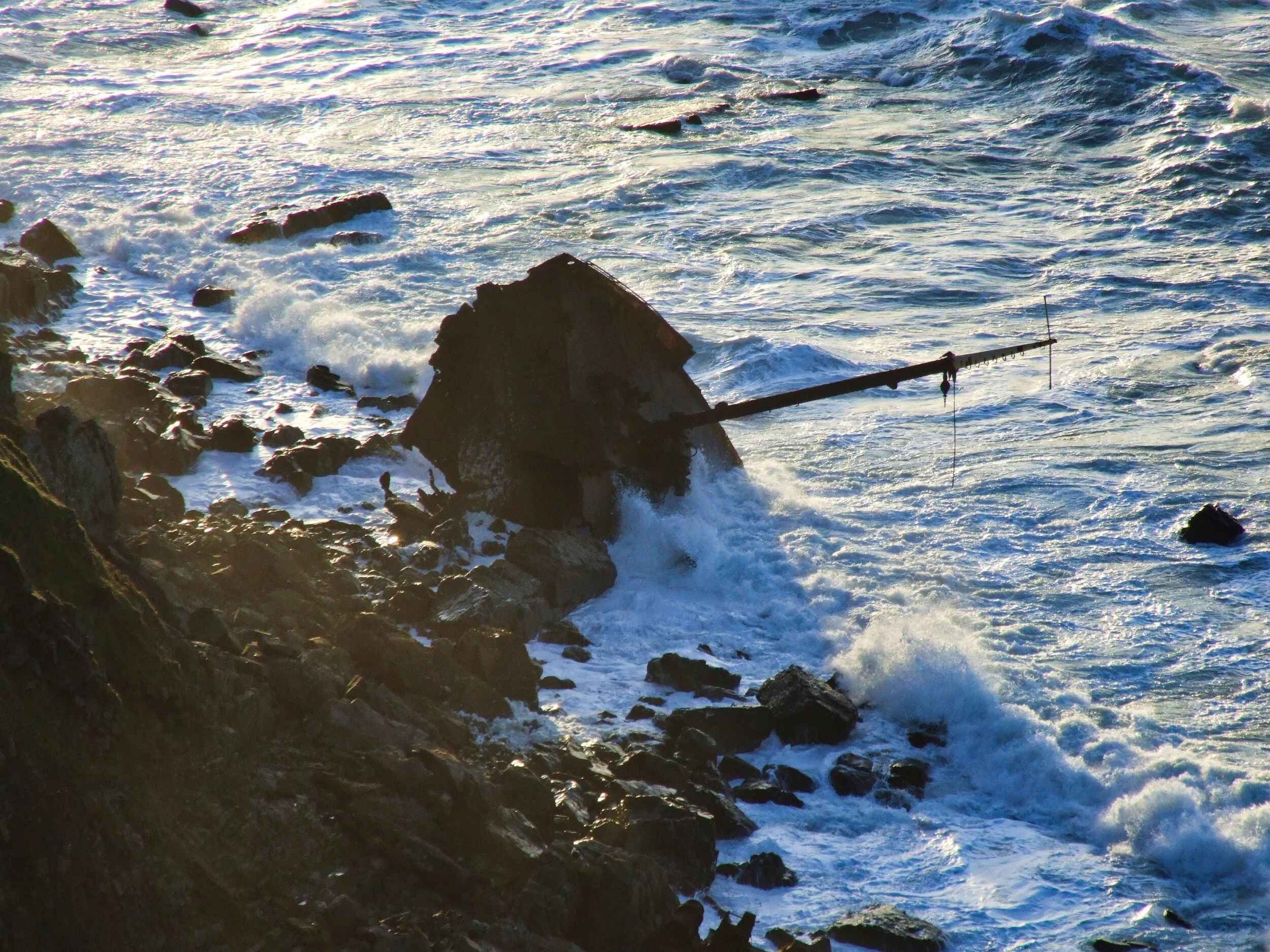
When it comes to place names, Welcome Mouth is a bit of a sick joke. Nowhere could be less welcoming. The men aboard the ships Maggie, Cornelia, Nancy, Leopoldin Baur, Edward Beck and Avonmore must have thought it to be the most inhospitable place on Earth as they wrecked upon its razor-backed reefs. All those vessels went to their doom hereabouts.
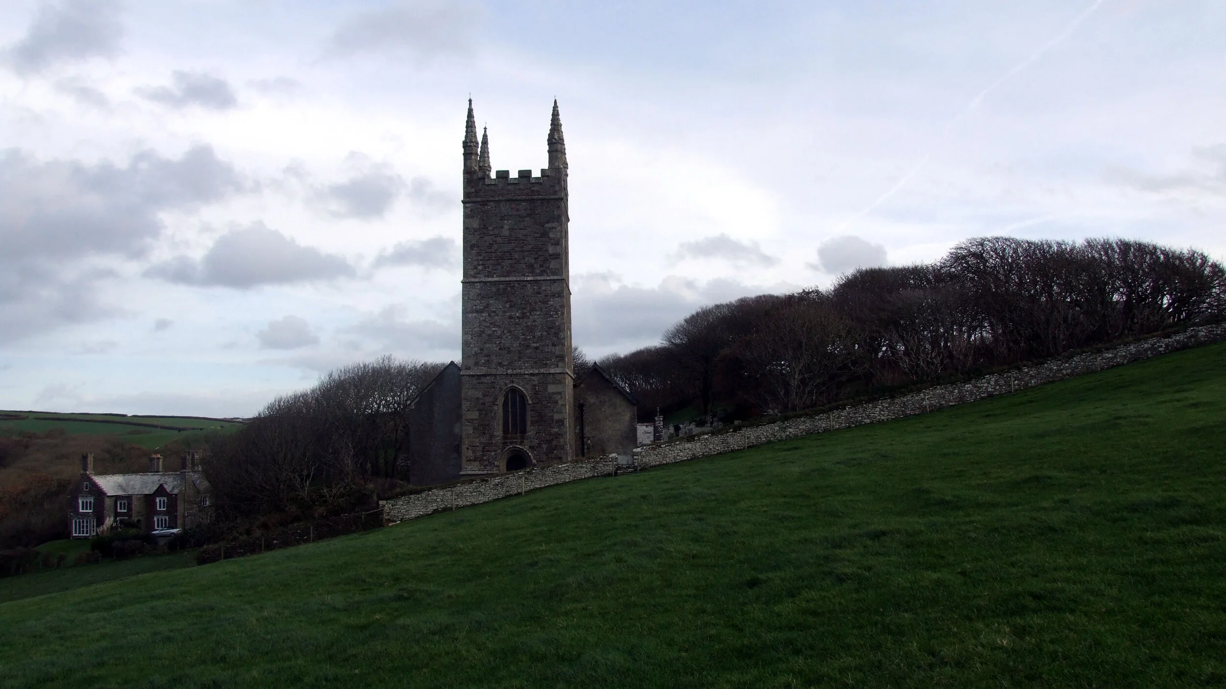
Travelling south again we come to atmospheric Morwenstow, the sepulchral hamlet which hangs above the razor rocks of Cotton Beach, Higher Sharpnose Point and cynically named Lucky Hole.

Morwenstow Church
The good folk of Morwenstow may have occasionally been called “wreckers” – but they probably never bothered resorting to setting up dodgy lights in order to lure ships to their doom. The wind, the sea and those terrible rocks are so well orchestrated in their overture of destruction, they need no help in dealing with little ships armed with nothing more than canvas wings. In the days of sail, such vessels caught off here in the wrong wind were mere moths in a storm

Morwenstow Cliffs
Morwenstow Church nestles in its wooded graveyard over-looking the sea. Rooks caw and flurry about in the wind which moans through the bent old trees as you cross the stile by the lych-gate and enter a demesne that seems to belong to another dimension.
Morwenstow Church from coast
That sensation used to be something to do with the white ship's figure-head that until recently dominated the cemetery. At the moment it’s away for renovation, but it used to mark the grave of Captain Peter and many of his sorry men, who died nearby, back in 1842.
They had been on the brig Caledonia, out from Rio de Janiero via Syra, Smyrna and Constantinople when her luck began to wane. It started when she reached the eastern Mediterranean where the cook was badly injured in a knife fight with an innkeeper.


What a rude awakening those wine and sun-soaked men must have had when they saw the cliffs of the Sharpnose one cold black dawn. Captain Peter ordered the men up the rigging as the Caledonia was pushed onto the rocks by the hard-blowing NNW gale, but no sooner had they climbed it the mast came down killing most of them.
There were only two survivors: a tortoise, which somehow managed to swim ashore to be collected by a local boy - and mariner Edward le Dain who was found, much be-draggled but alive, by a farmer the following morning.

Reverend RS Hawker
If he had any luck at all it was that he had washed up here during the time of the Reverend R.S. Hawker, the eccentric, intellectual and humanitarian parson. The famous old parson's hut (below) can still be visited down on the edge of the cliffs, thanks to the National Trust, and is reckoned to be one of the smallest buildings the organisation owns.
Gaze out at the ocean from the hut’s snug interior and you can almost feel the mental presence of Hawker next to you - puffing away at his opium, dreaming up new ideas such as the Church of England's Harvest Festival and writing lines like:


"And shall Trelawney die?
Here's twenty thousand Cornishman
Will know the reason why!"
Hawker also wrote about Bude, just a few miles down the coast:
Thus said the rushing raven/
Unto his hungry mate,/
Ho! Gossip! For Bude Haven/
There be corpses six or eight./
Cawk! Cawk! Said the raven,/
I am score years and ten/
Yet never in Bude Haven/
Did I croak for rescued men.
Parson Hawker knew only too well that Bude’s golden sands were simply a death trap. Here's a list of ships that foundered trying to either enter or leave the place in just two years, between 1867 and 1969: Alford, Ant, Capricorno, Elizabeth, Elizabeth Scown, Endeavour, Farmers Lass, Fortitude, Fusee 11, Giles Lang, Hawk, Island Belle, Kishon, Llandaff, Maria, Modeste Eugenie, Penally, President Garfield and Uncle John.

There were others, especially before the mid-nineteenth century, but then the wreckers were quick to tidy up before the authorities could salvage cargoes and rescue crew.

“Unless it is exceptionally fine weather you dare not stay out for the next tide,” I was once told by a local fisherman. “A depression out in the Atlantic can cause a big ground swell here and that means surf. And surf means trouble. You can get ten-foot waves.
“The trick is to ride just behind the wave - the opposite to a surfer,” he told me when I asked how on earth the boatmen tackled entering through big waves. “It's a bit strange because you can't see where you're going because of the wave.”

What the fishermen are heading for are the only lock gates that open directly into the Atlantic. They mark the end of the Bude Canal, built early in the 1820's to carry calcium rich sea sand to the farmers up in the Cornish and Devon hill-country where the soil was poor. It was a magnificent engineering feat and stretched nearly 35 miles from Bude to Launceston.
Like most canals, this one was put paid to by the coming of the railways - it finally closed in 1891. But, thanks to those ocean-facing locks, the port of Bude remained in commercial use until the 1930's. they have recently been renovated and now offer a welcome haven to pleasure boaters and fishermen.
Crackington Haven is the next indentation of any note along the coast, then we come to Boscastle – of late famed for its terrifying floods. But I recall much quieter times, sitting in the upturned bows of harbour-master Fred Siford's nautical garden feature surveying the human throng pouring over Cornwall's most secret port.

Crackington Haven

Crackington main beach
Secret, that is, if you try entering Boscastle from the sea. For mariners who don't know the coast, North Cornwall's unwelcoming cliffs present - with the exception of Bude and its dangerous sands - an impermeable curtain from Padstow to Hartland Point.
The fjord-like harbour at Boscastle is well disguised. A giant rock stack called the Meachard hides the entrance but, even if it didn't, you'd have difficulty spotting the gap in the curtain that would allow you to sneak into the one real haven in 40 miles. The tiny inlet twists and turns among its rocks in a determined attempt to hide the lush and verdant Valency Valley from the ocean's salty threat.
Boscastle has a foot in two parishes, which are divided by the religious sounding River Jordan. Forraburry and Minster are both ancient - there were people mulling over the area's municipal affairs as far back as the Bronze Age.
The people of the Iron Age settled a little bit later, and after that the Romans, then the Normans. A few remains of William de Botreaux’s castle can still be seen at the top of Dunn Street and many of Boscastle's older properties are based on thin strips of land that run down to the river and these are the remains of Norman burgage plots.

Now we come to a fascinating bit of coast near Willapark and Bossiney Cove. Rocky Valley is one of the West Country’s closest kept secrets – few people enter this amazing ravine which leads inland to famous, but little visited St Nectan’s Glen. From here there’s a walk to celebrated St Piran’s Well, which some people regard as being the most important place in Cornwall.
Even more legendary is much celebrated Tintagel Head and its world famous castle, otherwise known as The Island. English Heritage run the place nowadays and you must pay an entry fee if you want to explore the place where possibly good King Arthur was conceived.

Tintagel
We pass Tintagel Haven (where they once traded in boats, against all the odds) and climb towards Barras Nose, which was the first coastal property the National Trust ever owned. From up here you wonder at the antics of the old slate quarrymen who used to dangle hereabouts in their vertiginous attempts to relieve the cliffs of their booty.
“I live in a street with 32 addresses," says Port Isaac's former postmaster, Jon Cleave. "Only four of them are permanent homes.”

Port Isaac
Walk through the myriad cobbled streets of this most famous of tourist honey-pots on a winter's day and you'll witness the results of this remarkable statistic. There is a forsaken, deserted - even abandoned - demeanour about the place. Middle Street, Dolphin Street and Rose Hill all look pretty enough, but they're too pretty by half and so have become the part-time preserve of the well-healed from cities.

Rocks near Delabole
Second homes and holiday properties don't exactly rattle with life in the depths of winter and it is difficult now to imagine the days when village women would load thousands of tons of Delabole slate onto the schooners that used to ply in and out of here.
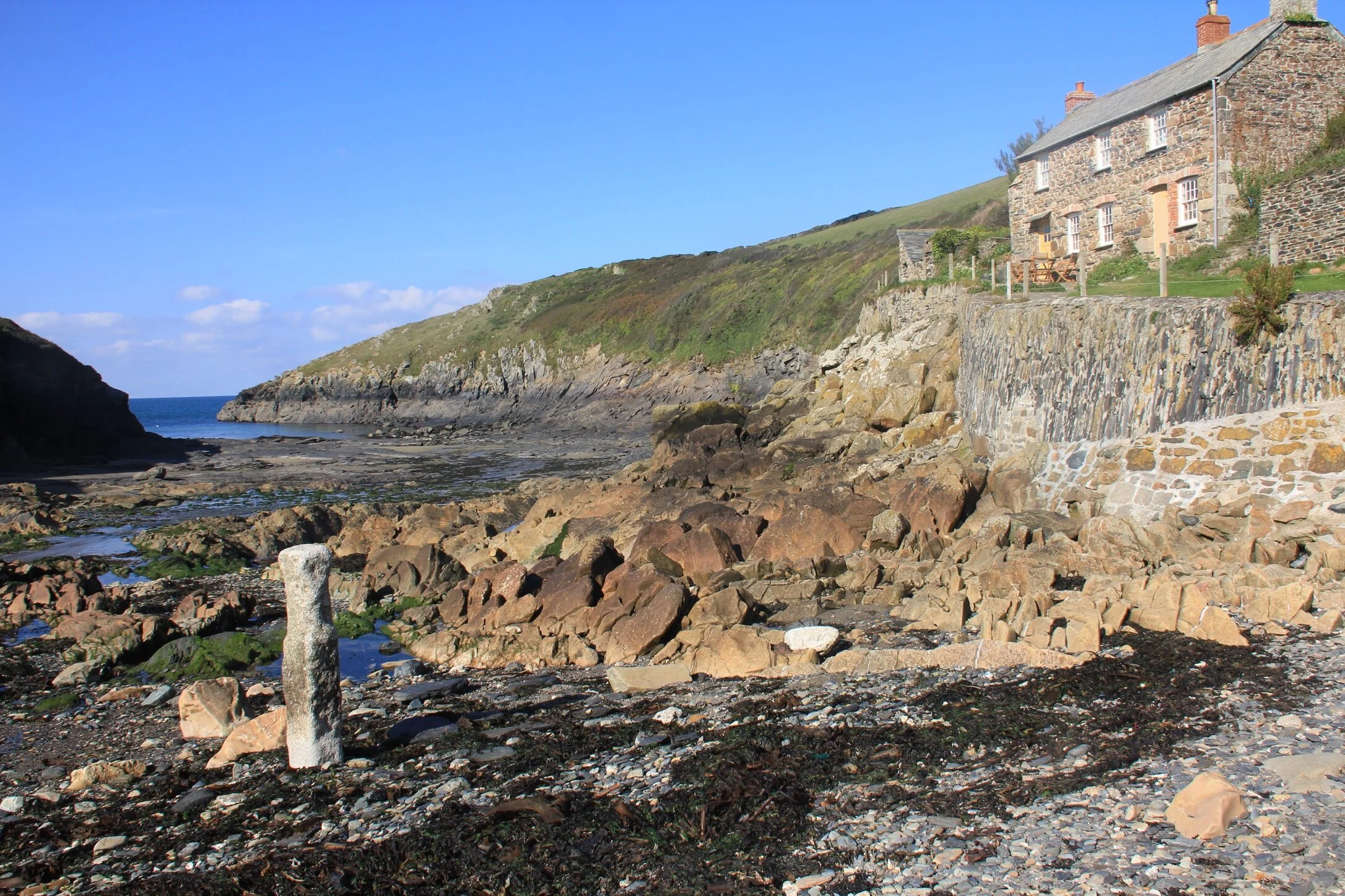
Somewhat fittingly, we leave the wreckers coast by visiting tiny, quiet Port Quin, which is the last stop before the coast rounds The Rumps and Pentire Head to reach the Camel Estuary and Padstow.

The Rumps
The entire male population of this once busy place was wiped out in a single terrible storm in the winter of 1697. Records have it that the village's herring fleet was completely destroyed, though it's not clear how many lives were lost.
But then, no one will ever know just how many thousands of poor sailors have met their ends along this beautiful, but terrible, coast.
Port Quin

